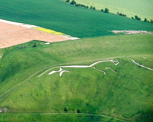
Uffington White Horse
The Uffington White Horse is a highly stylized prehistoric hill figure, 110 m long (374 feet), formed from deep trenches filled with crushed white chalk. The figure is situated on the upper slopes of White Horse Hill in the English civil parish of Uffington (in the county of Oxfordshire, historically Berkshire), some 8 km (5 mi) south of the town of Faringdon and a similar distance west of the town of Wantage. The hill forms a part of the scarp of the Berkshire Downs and overlooks the Vale of White Horse to the north. Best views of the figure are obtained from the air, or from directly across the Vale, particularly around the villages of Great Coxwell, Longcot and Fernham. The site is owned and managed by the National Trust.
The figure presumably dates to "the later prehistory", i.e. the Iron Age (800 BC–AD 100) or the late Bronze Age (1000–700 BC). This view was generally held by scholars even before the 1990s, based on the similarity of the horse's design to comparable figures in Celtic art, and it was confirmed following a 1990 excavation led by Simon Palmer and David Miles of the Oxford Archaeological Unit, following which deposits of fine silt removed from the horse's 'beak' were scientifically dated to the late Bronze Age.
Iron Age coins that bear a representation comparable to the Uffington White Horse have been found, supporting the early dating of this artifact; it has also been suggested that the horse had been fashioned in the Anglo-Saxon period, more particularly during Alfred's reign, but there is no positive evidence to support this and the view is classified as "folklore" by Darvill (1996).
Numerous other prominent prehistoric sites are located nearby, notably Wayland's Smithy, a long barrow less than 2 kilometres (1 mi) to the west. The Uffington is by far the oldest of the white horse figures in Britain, and is of an entirely different design from the others.
It has long been debated whether the chalk figure was intended to represent a horse or some other animal. However, it has been called a horse since the 11th century at least. A cartulary of Abingdon Abbey, compiled between 1072 and 1084, refers to "mons albi equi" at Uffington ("the White Horse Hill").
The horse is thought to represent a tribal symbol perhaps connected with the builders of Uffington Castle.
It is quite similar to horses depicted on Celtic coinage, the currency of the indigenous, pre-Roman-British population, and the Marlborough, Wiltshire bucket.
Until the late 19th century the horse was scoured every seven years as part of a more general local fair held on the hill. When regular cleaning is halted the figure quickly becomes obscured; it has always needed frequent work for the figure to remain visible.
In August 2002 the figure was defaced with the addition of a rider and three dogs by members of the "Real Countryside Alliance" (Real CA). The act was denounced by the Countryside Alliance.
In March 2012, as part of a pre-Cheltenham Festival publicity stunt, a bookmaker added a large jockey to the figure.
The Folkestone White Horse, Kent, is based on this horse. At Ciudad Juárez, Mexico, there is a larger replica of the Uffington horse.31°39′46.5″N 106°35′13.2″W[citation needed] There are two more replicas of the horse known, one in Cockington Green, Australia, and one in Georgia, United States.


.JPG/800px-Douvres_(4).JPG)
.JPG/800px-Douvres_(6).JPG)